Wednesday, May 29, 2013

Concord River

Hello everyone!

Yesterday I visited the Concord River, in Concord, near where Rt. 62E crosses Rt. 2. The Concord River is a tributary of the Merrimack River. It begins in Concord, where the Assabet and Sudbury Rivers combine and drains into the Merrimack in Lowell.

By using this guide that I posted a while ago, I was able to determine the that the Concord River is an mature river and its valley was most likely formed during the last ice age. Here are a few reasons why I came to this conclusion:

1. The Concord River has a relatively low gradient. At its greatest, the river has a gradient of around 5 to 5.5 feet per mile and at its lowest the gradient is less than one inch per mile. Since the gradient is low, the velocity is low as well, and therefore there is deposition as well as erosion. These are all traits of a mature river (River Stewardship Council).

As you can see in this photo, the Concord River has a low gradient and velocity in this location.

2. The Concord River also has a small flood plain. Mature rivers have small floodplains because they have experienced some flooding events, but not as many as old rivers. Each flooding event widens the floodplain, so if the mature river has experienced more floods than a young river but less than an old one, it makes sense for the floodplain to be small sized.

As shown here, the floodplain is quite small. 

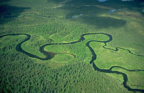
3. The Concord River also has slight meanders, signifying that it is mature. Meanders form when deposition and erosion occur on either side of the river. Slowly, the river begins to curve to the side of the erosion, making it so that the deposition occurs on the inside of the curve where the water is slowest and doesn't have the energy to carry as much sediment. This forms a feature called a point bar. The erosion happens on the outside of the meander because the water is moving faster and can pick up more sediment, forming a cut bank. It takes time for both cut banks and point bars to form and it takes time for the river to slow down enough for there to be deposition, so large meanders are generally associated with older rivers. Since these meanders are small, it means that the river is only just starting to slow down and develop these features.

This map shows almost the entire Concord River, and as you can see, the meanders are slight.

4. The Concord River also has a few small tributaries. The older the river, the more tributaries it has. Since this river has only a few, it must be mature as opposed to old in age.

This map shows a few of the small tributaries of the Concord River.

5. Additionally, the Concord River lacks many river features that are associated with old rivers. For example, there are not many oxbow lakes or meander cutoffs, and levees and meander scars are pretty nonexistent. Since it is a mature river it hasn't had enough time to develop these features yet.

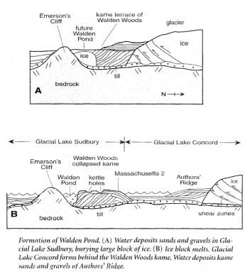
6. Additionally, the Concord River Valley was formed by glaciers. We know this because of the shape of the valley. Glaciers carve U-shaped valleys since they erode on all sides (except the top, obviously), while rivers create V-shaped valleys since they only erode downwards. The Concord River Valley is more U-shaped than V-shaped, so it was carved by glaciers.

Have a fantastic day!

Image Citations:
Maps copyright Google Maps

Fairyland Pond

The path to Fairyland Pond

Hello everyone!
Recently, I took a little field trip to Concord to see Fairyland Pond. It is across the street from Concord-Carlisle High School, about 500 feet into the woods.

Looking across the pond. You can sort of tell how steep the surrounding land is.

Fairyland Pond is about 450 feet long and on average around 190 feet wide. It is very shallow; the maximum depth is only 4 feet. Fairyland pond is a kettle lake. If you don’t know what that is, please head on over here to learn more about this awesome feature. There are also many steep sides surrounding the pond. These steep sides are kames, features that forms when sediment accumulates on top of the glacier and is then deposited on the ground as a hill when the glacier melts. To learn more about kames, please click here. Together, these two features form a kame and kettle landscape which is very common in glacial outwash plains.


Another angle of the pond.

How do we know that Fairyland pond is a kettle lake and not just a regular lake? Well, normal lakes rely on rivers to constantly supply them with water, so there are typically many streams flowing in and out of them. Kettle lakes, however, are special. They get their water when the outwash from the glacier drains into them. Therefore, it is uncommon for there to be streams flowing into them, supplying them with water. That is the case for Fairyland Pond, there is only a small brook that drains out of it.


This map shows the steepness of the kames around the pond, as well as the solitary stream running out of it.

Tessie had a ton of fun walking around Fairyland Pond with me and hopes you have a fantastic day!


Image Citation:
Map copyright Google Maps

Tuesday, May 28, 2013

Acton Arboretum

Map of the Acton Arboretum. The esker is located on the southwestern tip of the Blog Loop.


Hello everybody!

Today I went to the Acton Arboretum, home of a special glacial feature: an esker! If you would like to learn more about how an esker forms, please check out this post.


Looking up to the top of the esker.

This esker is located on the southern tip of the Bog Loop Trail, one of the many paths in the arboretum. It was about 20 feet high and it runs north-south, which indicates that the glacier moved in that direction as well, since eskers typically run parallel to the direction of glacial flow.
The esker was made of well sorted sediment, which makes sense since all of the sediment would have been deposited by water. In fact, the stream that deposited all of the sediment to create this esker was one of the tributaries that fed glacial lake Sudbury many years ago.


The view down one side of the esker.


The view down the other side of the esker.

Another thing I noticed while I was walking through the Arboretum was how many stone walls there were throughout the woods. During colonial times, farmers would remove the stones used to make these walls out of the ground that they were plowing. One of the reasons that stone walls are so abundant in this area is because the soil is glacial till, sediment that was shoved along and eroded under the glacier. Glacial till is poorly sorted, so having large rocks in it is very common. Unfortunately, it does not lead to easy farming...

The Acton Arboretum is also renowned for its flowers, and when I visited, many were in full bloom.


Have a fantastic day!

Image citations:
Arboretum Map. Digital image. Acton Conservation Land. N.p., n.d. Web. 26 May 2013. <http://www.actontrails.org/images/mArboretum.jpg>.


Author's Ridge

The top of the kame delta (you can use the headstones as a reference for scale)


Hello everyone!


    Yesterday Tessie and I went to Author’s Ridge in Concord, Ma to look at the kame delta that is located there.
   
 If you would like to learn about how a kame delta forms in general, please head on over to this post that I wrote awhile ago.
  
 This kame delta in particular formed when the Laurentide Ice sheet reached to just north of Massachusetts Route 2. There, meltwater flowed off of the glacier into Lake Sudbury, which was just south of there, creating this feature. We know that the glacier was located north of the Author’s Ridge due to the direction of the layers of sediment. The layers are parallel to the southwestern, steeper side of the ridge, which means that the meltwater from the glacier that deposited the sediment flowed down that side. This means the ice contact slope was the other (northerneastern side). That then tells us that Glacial Lake Concord was southwest of the kame delta, since the meltwater ran down the southwestern slope into the lake.

This map shows the direction of the layers of sediment on the Kame Delta.


The view down the side of the delta that the sediment is parallel to. 

The view down the ice contact slope of the kame delta.

We also know that the glacier was moving northeast to southwest due to the direction the ridge is running. The kame delta runs southeast to northwest. These features always form parallel to the snout of the glacier, so the snout must have been running east-west. Glaciers always more perpendicular to the snout, so the glacier moved northeast to southwest.

Here's a little map that I made showing the relative location of the delta, the lake and the glacier.

Have a fantastic day!


Image Citations:

Formation of Walden Pond. Digital image. Geology of Middlesex County. N.p., n.d. Web. 26 May 2013. <http://middlesexgeology.weebly.com/uploads/2/3/8/5/2385615/3232311.jpg?345x383>.


Drumlin Farm


Hello everyone!

    I recently visited Drumlin Farm in Lincoln. As you have probably guessed based on the name, a drumlin is located there. It is a great spot, with many trails that lead you around and on top of the drumlin and in the fields surrounding the farmyard.
    
 This drumlin was about 270 ft tall and around 1,050 ft long. If you don’t know what a drumlin is, please pop on over to this post to learn more about them.
    
 The steepest side of the drumlin was the eastern slope and the side with a more gradual slope was the western one. As you know, a drumlin forms when the glacier bulldozes the sediment in front of it forward. Eventually, the glacier then either stops pushing and glides over the hill of sediment that accumulated at its snout, or, meltwater runs from the top of the glacier down the hill of sediment. In either case, this results is an asymmetrical hill, or a drumlin. Therefore, you can determine the direction the glacier was moving by looking at the steepness of its sides. The glacier always would have moved in the direction the gradual side is facing. Therefore, the when the Laurentide Ice sheet created this drumlin, it was moving from east to west because the gradual side of the drumlin is facing north.

As shown here, the steep side of the drumlin was the eastern side while the gradual one was the western side, indicating that the glacier moved from east to west.


This is a view down the gradually sloping side of the drumlin.


This is a view looking up a steeper side of the drumlin.

    Also, at the top of the drumlin, I noticed a large boulder on top of the drumlin. It is an erratic, a rock that was displaced from its original location by the glacier.  I climbed up on it, and from the top I could see spectacular views of many of the towns surrounding Lincoln.


The erratic


The view from atop the erratic

    I couldn’t leave Drumlin Farm without looking at the animals, so with the time I had left I took a quick peek into the barnyard. Since it is the spring, there were many adorable baby animals playing outside, enjoying the beautiful spring day.


A couple of kids


A little lamb

Have a fantastic day!


Image citation:
Map copyright Google Maps

How To Determine the Age of a River

* Please note: rivers and streams are interchangeable terms, they are not separate features. *


As they age, rivers change dramatically. Here are a few features that will help you determine the age of a river.


This is a young river due to its high elevation and V-shaped valley.

Young Rivers:
- They typically form near drainage divides, areas where on watershed meets another. These divides are at high elevations.
- Young rivers have high gradients due to the fact that they have not had enough time to down cut (erode downwards) to base level.
- However, they want to get to base level, so there is a lot of downcutting.
- They have a high velocity due to their high gradients, and therefore erode much more than they deposit.
- The material at the banks of young rivers are very prone to mass wasting because of all the erosion from the stream.
- The river cuts a v-shaped valley as it erodes.
- Due to the high gradient and velocity, there are many rapids and waterfalls.
- Young rivers are generally very straight because there hasn’t been enough deposition to form meanders yet.


The Amazon River is a mature river because of its slight meanders and it has a few tributaries.

Mature Rivers:
- This is the point in which the river is halfway between being young and old, so it has some features similar to an old river, and some similar to a young one.
- Mature rivers develope a small floodplain on either side of the channel due to deposition from flooding events
- It begins to form slight meanders as the deposition increases in some locations.
- A few tributaries may start to feed into a mature river.
- A mature stream is called a “graded stream” which means that the erosion and deposition are in balance


This river is old due to its large meanders, many tributaries, large floodplain, and meander scars.

Old Rivers:
- In old rivers, there are very large meanders that have formed by the deposition and erosion over time.
- Features such as oxbow lakes and meander scars are present, showing that the river has changed course.
- There is a large floodplain, formed by many flooding events.
- It has a very low gradient since the mouth will have reached nearly base level from all the downcutting earlier in its life.
- Since the gradient is low, old streams have low velocities as well.
- Because the velocity is low, there is more deposition since the water doesn’t have the energy to carry the sediment.

By looking at the river and identifying its various features, it is relatively easy to determine a river’s relative age.

Have a fantastic day!


Image Citations:

Old, meandering river. Digital image. Geocaching. Groundspeak, Inc., 22 July 2010. Web. 27 May 2013. <http://img.geocaching.com/cache/5f2f82d5-11a4-44ef-9f00-f22f5ef0f0c2.jpg>.

Young River. Digital image. Geonet. N.p., 2 Oct. 2007. Web. 30 May 2013. <http://info.geonet.org.nz/download/attachments/951751/young-river-30-09-2007-3.jpg>.

UC Berkeley. Amazon River. Digital image. Treehugger. MNN Holdings, LLC, 8 Feb. 2010. Web. 27 May 2013. <http://media.treehugger.com/assets/images/2011/10/amazon-river-hydropiracy.jpg>

River Features


Feature Fact File: River features


There are many features on a river, but here is a brief description of a few of them:

Meanders - The bends in the river. They form when the water in a river encounters more friction on one side of the channel than the other, so the water on each side moves at different speeds. The faster water has more energy so it erodes more, while the slower moving side had less energy and deposits more. Therefore over time, the river curves towards the side where the erosion is occurring, forming meanders.


Meander Cutoffs - A shortcut for the river across the riverbed. The river decided that it doesn’t want to go around the entire meander, so it cuts across the river bank.

Oxbow Lakes - Abandoned meanders. When the meander cutoff becomes the preferred way to travel, deposition from the meander cutoff can separate the meander from the rest of the river, creating an oxbow lake.


Point Bar - The inside of a meander where a mini sandbar is formed from all the deposition. The water encounters more friction on this side so it slows down, losing energy. It no longer has enough energy to carry the sediment, so it is deposited here, forming a point bar.

Cutbanks - The outside of a meander where there is a lot of erosion. The river moves faster here since there is less friction. Therefore the water has more energy and can carry a lot of sediment, so it erodes a lot.


Floodplains -The area around the river made of fine grained material that would be underwater in a flooding event.

Levees - Sandy ridges running parallel to the river. When a river floods, the largest material is deposited first on the edge of the river, forming the levees.


Crevasse Splay - A place where water has broken through a river and splays out onto the floodplain.


Yazoo Streams - Smaller streams running parallel to the river. They form after a flooding event when the water reorganizes itself into a this smaller stream. Yazoo streams indicate that the floodplain is very large.

Meander Scars - Marks on the river bank where meanders once were but have since moved. There is usually deposited material there.


Have a fantastic day!


Image Citations:


Crevasse Splay. Digital image. GeoDZ.com. N.p., n.d. Web. 27 May 2013. <http://www.geodz.com/deu/d/images/1674_crevasse_splay.png>.

Diagram of erosion and deposition on a river. Digital image. Peru. N.p., 3 May 2011. Web. 27 May 2013. <https://blogger.googleusercontent.com/img/b/R29vZ2xl/AVvXsEhrd3zYWdlF8vZdRVVoAn2Edvirtxi0lriCnDFoJ832G-lQ965FWPR6wwXTAepPCkq1YD0o3hrlTd0NnQNVmCRtvMJL3SyshVoOm5DxIuuvaChfCk16jEGRavW3hHLvoOYr1qNV2kaRlmW1/s1600/PointBarCutBank.jpg>.

Diagram of the formation of an oxbow lake. Digital image. Rashid's Blog. N.p., 27 Apr. 2011. Web. 27 May 2013. <http://cgz.e2bn.net/e2bn/leas/c99/schools/cgz/accounts/staff/rchambers/GeoBytes%20GCSE%20Blog%20Resources/Images/Rivers/ox-bow_lake.gif>.

Floodplain and Levees. Digital image. Floodplains. N.p., n.d. Web. 27 May 2013. <http://www.angelfire.com/hero/gerald_koh_s9029362a/images/floodp14.jpg>.

Lemke, K. A. River features. Digital image. Glogster. N.p., n.d. Web. 27 May 2013. <http://c3e308.medialib.glogster.com/media/d5/d56c1133c70dddbee9cadaec284485495a1c640683dbd4920338ea1011dd8cf2/floodplain1-gif.gif>.

Wechsler, Doug. Meanders. Digital image. Salt Marsh Life. N.p., n.d. Web. 27 May 2013. <http://saltmarshlife.com/image/Saltmarsh%20meanders%202903-66.jpg>

Kettle Holes

A kettle hole in Iceland

Feature Fact File: Kettle holes and lakes

What are kettle holes?
    Kettle holes are depression in the ground that have very steep sides. They can fill up with water to form lakes or ponds.

How do kettles form?
    Kettle holes form when a chunk of ice that is separated from the glacier is buried by sand. They are very large pieces of ice, so they form a depression where they sit. Eventually, the ice melts, leaving behind a hole.


How a kettle hole forms.


Where do kettles form?
    Kettles form in the outwash plain of a glacier.

Have a fantastic day!


Image Citations:

Ingólfsson, Ólafur. Kettle Hole in sandur sediments, in front of the 1890 Brúarjökull surge moraine. Digital image. Ólafur Ingólfsson. N.p., 2004. Web. 26 May 2013. <https://notendur.hi.is/oi/Eyjabakkajokull%20photos/Kettle%20hole.JPG>.

Kettle Hole Formation. Digital image. Cairngorm Landscapes. N.p., n.d. Web. 26 May 2013. <http://www.landforms.eu/cairngorms/images/kettle-hole.gif>.